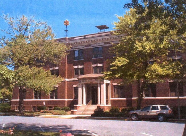
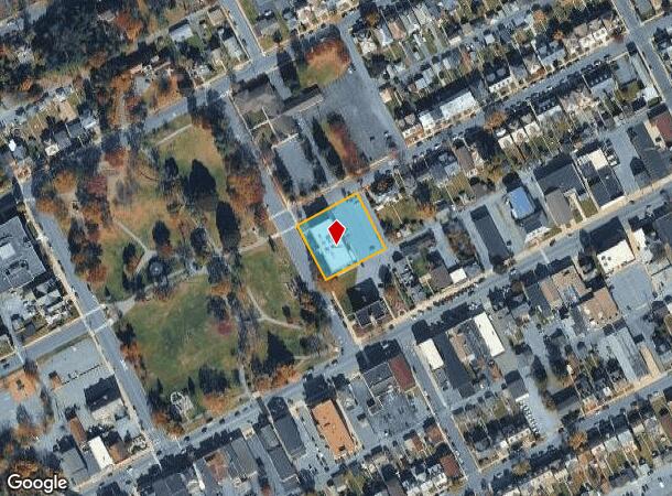
Property Record
4Th St At Franklin Ave, Palmerton, PA 18071
NEARBY LISTINGS FOR SALE OR LEASE
-
-
View all Palmerton listings for sale on LoopNet.com
Property Detail
4Th St At Franklin Ave
42A-48-D3.01
Carbon
Publicschool
Pennsylvania
2025
0.68 AC
2025
Lehigh Valley
020801
Philadelphia
1,188 SF
Allentown-Bethlehem-Easton, PA-NJ
DEMOGRAPHICS near 4Th St At Franklin Ave
1 Mile
3 Mile
5 Mile
2024 Total Population
4,858
10,596
29,085
2029 Population
4,894
10,649
29,270
Pop Growth 2024-2029
+ 0.74%
+ 0.50%
+ 0.64%
Average Age
42
44
44
2024 Total Households
2,098
4,463
12,033
HH Growth 2024-2029
+ 0.81%
+ 0.54%
+ 0.66%
Median Household Inc
$60,191
$60,417
$63,959
Avg Household Size
2.30
2.30
2.40
2024 Avg HH Vehicles
2.00
2.00
2.00
Median Home Value
$152,306
$178,008
$199,274
Median Year Built
1951
1961
1967
Nearby Places
- Restaurants
- Banks
- Shops
- Fitness
- Groceries
PUBLIC TRANSPORTATION
AIRPORT
Lehigh Valley International
DRIVE
WALK
Distance
Lehigh Valley International
34 min
20.2 mi
Nearby Properties
Address
Land Use
TOTAL SIZE
Lot Size
Zoning
Address
Land Use
TOTAL SIZE
Lot Size
Zoning
101,962 SF
28.02 AC
SR
Address
Land Use
TOTAL SIZE
Lot Size
Zoning
112,243 SF
18 AC
SR
Address
Land Use
TOTAL SIZE
Lot Size
Zoning
784.80 AC
BM
Address
Land Use
TOTAL SIZE
Lot Size
Zoning
3,325 SF
55.50 AC
Address
Land Use
TOTAL SIZE
Lot Size
Zoning
1.05 AC
Address
Land Use
TOTAL SIZE
Lot Size
Zoning
235,207 SF
11.35 AC
I
Address
Land Use
TOTAL SIZE
Lot Size
Zoning
5,534 SF
181.51 AC
BM
Address
Land Use
TOTAL SIZE
Lot Size
Zoning
118,072 SF
12.69 AC
R40
Address
Land Use
TOTAL SIZE
Lot Size
Zoning
640 SF
10 AC
Address
Land Use
TOTAL SIZE
Lot Size
Zoning
816 SF
0.35 AC
Address
Land Use
TOTAL SIZE
Lot Size
Zoning
3,751 SF
56.46 AC
I
Address
Land Use
TOTAL SIZE
Lot Size
Zoning
1,100 SF
40.77 AC
Address
Land Use
TOTAL SIZE
Lot Size
Zoning
44.92 AC
RA
Address
Land Use
TOTAL SIZE
Lot Size
Zoning
132.20 AC
BM
Address
Land Use
TOTAL SIZE
Lot Size
Zoning
1,344 SF
3.56 AC
Address
Land Use
TOTAL SIZE
Lot Size
Zoning
137.56 AC
Address
Land Use
TOTAL SIZE
Lot Size
Zoning
682.58 AC
RA
Address
Land Use
TOTAL SIZE
Lot Size
Zoning
29.19 AC
SR
Address
Land Use
TOTAL SIZE
Lot Size
Zoning
4,020 SF
25.30 AC
Address
Land Use
TOTAL SIZE
Lot Size
Zoning
1,240 SF
2.62 AC
Address
Land Use
TOTAL SIZE
Lot Size
Zoning
1,100 SF
8.01 AC
Address
Land Use
TOTAL SIZE
Lot Size
Zoning
0.35 AC
Address
Land Use
TOTAL SIZE
Lot Size
Zoning
1,557 SF
1.34 AC
Address
Land Use
TOTAL SIZE
Lot Size
Zoning
9,680 SF
47.60 AC
I
Address
Land Use
TOTAL SIZE
Lot Size
Zoning
4,132 SF
5.10 AC
BM
Address
Land Use
TOTAL SIZE
Lot Size
Zoning
Address
Land Use
TOTAL SIZE
Lot Size
Zoning
2,168 SF
0.52 AC
Address
Land Use
TOTAL SIZE
Lot Size
Zoning
768 SF
0.85 AC
Address
Land Use
TOTAL SIZE
Lot Size
Zoning
1,400 SF
6.79 AC
I
Address
Land Use
TOTAL SIZE
Lot Size
Zoning
49.88 AC
BM
The World's #1 Commercial Real Estate Marketplace
Connect with us
© 2025 CoStar Group
The information above has been obtained from sources believed reliable. While we do not doubt its accuracy we have not verified it and make no guarantee, warranty or representation about it. It is your responsibility to independently confirm its accuracy and completeness. Any projections, opinions, assumptions, or estimates used are for example only and do not represent the current or future performance of the property. The value of this transaction to you depends on tax and other factors which should be evaluated by your tax, financial, and legal advisors. You and your advisors should conduct a careful, independent investigation of the property to determine to your satisfaction the suitability of the property for your needs.